
Geostationary Operational Environmental Satellite (GOES)
Overview
Geostationary Operational Environmental Satellite (GOES) is a network of weather satellites built and launched by NASA and operated by National Oceanic and Atmospheric Administration (NOAA). The GOES program covers NOAA’s forecasting area, which extends from Guam to the west coast of Africa and roughly corresponds to the Western Hemisphere.[1], [2]
GOES satellites maintain a fixed position over the surface while orbiting the Earth, providing continuous coverage of the region. The satellites passively sense electromagnetic energy (e.g., heat, visible light) that indicates the presence of clouds, water vapor, and surface features. In this way, GOES closely monitors atmospheric conditions (our weather and climate) and solar activity (space weather), collecting near-real-time images and data.[1], [3]
GOES enables meteorologists to track and predict local weather events (thunderstorms, tornadoes, fog, hurricanes, floods, and other severe weather events), as well as solar storms, which can precipitate communication and navigation disruptions and power outages. The GOES satellite network has also proven useful for monitoring other major events that affect the atmosphere, such as dust storms, volcanic eruptions, and forest fires, providing timely and potentially life-saving information for those on the ground.[4], [5], [6]
GOES satellite data is used for many other purposes as well, such as estimating snowfall accumulations, mapping the movements of sea and lake ice, analyzing sea surface temperature data as it relates to the health of marine life, and supporting SARSAT (the search-and-rescue satellite aided system).[7], [8], [9]
Images from GOES satellites may be viewed through NOAA NESDIS (National Environmental Satellite Data and Information Service) or the NASA Earth Science Office.
GOES Fleet and Satellite Status
GOES satellites are designated with a letter prior to launch, but once a satellite has achieved orbit, it is assigned a number.[3] The status of all GOES satellites (past and present) is available on the GOES-R Mission History page, with more detailed GOES Operational Status updates from NOAA. A GOES flyout schedule (timeline) is also available from NOAA NESDIS.
Fleet Configuration
GOES uses a 2-satellite system, implemented with the previous GOES N-Series (GOES N-P/13-15). The fleet has 2 operational positions: GOES East and GOES West. The satellite operating as GOES East monitors the Americas and the Atlantic Ocean to the west coast of Africa, while GOES West is positioned to cover the western contiguous United States, Alaska, Hawaii, Mexico, Central America, and the Pacific Ocean to New Zealand. An on-orbit spare satellite is maintained at all times to serve as a backup, should a problem occur with either operational satellite, GOES East or West.[2], [3], [10]
Currently Flying and Retired Satellites
GOES satellites A-M/1-12 have all been decommissioned. GOES-N/GOES-13 (now EWS-G1) was transferred to the U.S. Space Force in 2018, to has become the first satellite in the Electro-Optical Infrared Weather System (EWS) program. EWS-G1 is currently in geostationary orbit over the Indian Ocean, providing weather forecasting data for the Department of Defense.[3], [11]
The GOES satellites currently in operation are GOES-O (GOES-14), GOES-P (GOES-15), GOES-R (GOES-16), GOES-S (GOES-17), and GOES-T (GOES-18). GOES-16, launched in 2016, and GOES-17, launched in 2018, are in operation as GOES East and GOES West, respectively. The older satellites GOES-14 and GOES-15 (part of the previous generation, GOES N-P/13-15) are on-orbit spares.[3]
GOES-T (now GOES-18) is the newest GOES satellite, launched on March 1, 2022. GOES-18 is moving into the GOES-West position to replace GOES-17 in early 2023, at which point GOES-17 will become an on-orbit spare. The final satellite in the current GOES-R Series, GOES-U, is planned to launch in April 2024.[2], [7], [10]
From GOES-R Series to GeoXO
The current generation of satellites is GOES-R Series, a 4-satellite program that includes GOES-R, GOES-S, GOES-T, and GOES-U. GOES-R Series was designed to improve upon the existing GOES system by enabling increased spatial resolution of GOES imagery and faster coverage for more accurate forecasts, providing real-time mapping of lightning activity, improving solar activity and space weather monitoring. Most importantly, GOES-R Series has extended the operational life of the GOES network through December 2036. [2], [4], [12]
Implementation of NASA and NOAA’s next-generation geostationary satellite mission, named GeoXO (Geostationary Extended Observations system), is slated for the early 2030s. Planned improvements encompass visible/infrared imagery and lightning capabilities, nighttime visible imagery, hyperspectral sounding, atmospheric composition, and ocean color observations.[13]
The GeoXO mission’s preliminary timeline is available through NOAA NESDIS. GeoXO’s Industry Collaboration page hosts procurement notices (RFIs and RFPs) and a list of contracts awarded for “Phase A” studies that are part of the mission’s formulation activities.
Key Stakeholders
NOAA manages the GOES-R Series Program through an integrated NOAA/NASA office and oversees the acquisition of the program’s ground system. NOAA is also responsible for satellite operation and distribution of GOES data, and mission operations are performed at NOAA’s Satellite Operations facility in Maryland.
NASA oversees the acquisition of spacecraft, instruments and launch vehicles. NASA’s Goddard Space Flight Center in Maryland manages spacecraft and instrument acquisition and built the Magnetometer for GOES-T and for the future GOES-U. The Launch Services Program at NASA’s Kennedy Space Center in Florida is responsible for launch vehicle acquisition.[14]
Prime Contractors
Additionally, while Lockheed Martin Space Systems is responsible for spacecraft development, integration and testing, L3Harris Technologies provides the main instrument payload, Advanced Baseline Imager, and ground system, which includes an integrated antenna system.[7], [15], [16] United Launch Alliance provided the Atlas V 541 launch service for GOES-R, S, and T. SpaceX will provide Heavy Falcon launch services for GOES-U, scheduled to launch in April 2024.[17], [18]
NOAA-NASA GOES-R & GeoX Organizational Chart
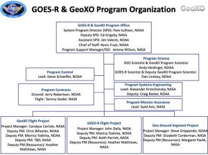
Source: NOAA/NASA GOES-R [19]
Instruments
GOES-R Series Instruments
The 3 main GOES-R series instrument types are: nadir-pointing (ABI and GLM); solar-pointing (EXIS, SUVI, and CCOR); and in-situ (SEISS and MAG).[20]
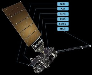
Source: NOAA NESDIS [21]
- Advanced Baseline Imager (ABI): ABI is a multi-channel, passive imaging radiometer and the satellites’ main instrument for imaging Earth’s surface and atmosphere, producing 65% of all GOES data. ABI takes readings in 16 different spectral bands (2 visible light, 4 near-infrared, and 10 infrared channels) of the Earth’s surface, atmosphere, and cloud cover and provides variable area imagery at 30-second – 15-minute intervals. ABI data is used to monitor cloud formation, precipitation, aerosols and air quality, land surface temperature, ocean temperature and movement, and vegetative health, among other things.[22], [23], [24]
- Compact Coronagraph (CCOR): CCOR is a newly developed space weather instrument, the 1st of which will fly with GOES-U when it launches in 2024. CCOR is designed to capture white-light imagery of the solar corona (outer atmosphere) and coronal mass ejections (CMEs). CMEs are the principal cause of geomagnetic storms, which in turn can do extensive damage to power grids, satellites, and communication and navigation systems. CCOR will provide more timely information on CMEs and better forecasting of resulting geomagnetic storms.[25]
- Extreme Ultraviolet and X-Ray Irradiance Sensors (EXIS): EXIS is a space weather instrument used to monitor solar irradiance in the upper atmosphere. EXIS contains 2 main sensors—the Extreme Ultraviolet Sensor (EUVS) and the X-Ray Sensor (XRS), as well as the Sun Positioning Sensor (SPS) subsystems. EUVS monitors solar extreme ultraviolet (UV) irradiance and detects solar activity that impedes low Earth orbit satellites and may lead to radio blackouts. XRS measures solar X-ray irradiance and helps predict solar proton events that can penetrate the Earth’s magnetic field—impeding communications, navigational systems, and power grid performance.[5], [26], [27]
- Geostationary Lightning Mapper (GLM): The first operational sensor of its kind in geospatial orbit, GLM is a single-channel, near-infrared optical transient detector that continuously detects and maps lightning activity (in-cloud, cloud-to-cloud, and cloud-to-ground) over the Western Hemisphere, at a spatial resolution of approximately 10 km. GLM data on the intensity of lightning activity and the distance traveled by ground strikes enables early warnings of severe weather hazards.[28], [29]
- Magnetometer (MAG): MAG monitors the magnetic field at the outer region of the Earth’s magnetosphere. MAG’s geomagnetic field readings help detect and provide timely warnings of magnetic storms that can imperil satellites, spacecraft, and the power grid.[5], [30]
- Space Environment In-Situ Suite (SEISS): SEISS is an instrument that measures fluctuations of charged particles in the Earth’s magnetosphere through 4 sensors: the Energetic Heavy Ion Sensor (EHIS), the Magnetospheric Particle Sensors - High and Low (MPS-HI and MPS-LO), and the Solar and Galactic Proton Sensor (SGPS). SEISS data is used to help protect high-altitude aircraft and astronauts from ionizing radiation; satellite hardware, navigation systems, and sensors from electrostatic discharge damage; and radio communications and commercial air traffic near Earth’s poles from disruption and blackout. [5], [31]
- Solar Ultraviolet Imager (SUVI): SUVI is a telescope that captures solar extreme ultraviolet (UV) irradiance in 6 UV wavelengths and compiles high-resolution, full-disk images of the sun at those wavelengths. SUVI solar data and images are used to supply satellite operators, telecom providers, and electric power companies with early warnings of potential space weather hazards. [5], [32], [33]
GeoXO Instruments
The suite of instruments for the next generation of GOES satellites has not been finalized, but NOAA/NASA plan that GeoXO satellites will include the following:
- GeoXO Lightning Mapper (LMX)
- GeoXO Atmospheric Sounder (GXS)
- GeoXO Ocean Color Instrument (OCX)
- GeoXO Atmospheric Composition Instrument (ACX)
- GeoXO Night Band
- GeoXO Imager (GXI). [34]
Updated November 2022 by Desirae Zingarelli-Sweet
Comments are closed.